
When I think of memorable scenes from my first viewing of the Twin Peaks pilot episode, I’m reminded of Ronette Pulaski, bruised and battered, stumbling across an old railroad bridge. It’s a haunting image that begs for answers – Who did this? How did she escape? (luckily, some answers were provided in Twin Peaks: Fire Walk With Me). The bridge she crosses, however, remains a mysterious and iconic location in the Twin Peaks universe. This Setting the Stage article explores the bridge’s history, appearances in a handful of episodes, and the changes it’s experienced through the passage of time.
WHERE IS RONETTE PULASKI’S BRIDGE LOCATED IN TWIN PEAKS?

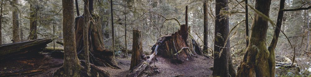
The Reinig Road bridge is located at 40413 SE Reinig Road in Snoqualmie, Washington. It’s located very close to the film locations for “Welcome to Twin Peaks” sign, Cooper entering the town, and the Sparkwood & 21 Intersection.
Upon entering the town of Twin Peaks, Special Agent Dale Cooper mentions he is headed to the Intensive Care Unit at Calhoun Memorial Hospital to “take a look at that girl who crawled down the railroad tracks off the mountain.”

In an earlier version of this article, I wrongly assumed that Ronette crossed from Canada to Washington State (top image). But ObnoxiousandAnonymous pointed out that she most likely crossed from Idaho, which prompted the involvement from the FBI. According to Justia.com:
“Federal authorities may also prosecute certain crimes that, while normally handled by the states, become federal offenses by crossing from one state to another.”
If Ronette never crossed from Idaho to Washington state, I wonder if Cooper would have ever been dispatched to Twin Peaks.
BRIEF HISTORY OF RONETTE PULASKI’S BRIDGE IN THE REAL TWIN PEAKS

The bridge was constructed in 1916 that was part of “the Chicago, Milwaukee, St. Paul & Pacific’s Everett Branch (CMStP&P), once an important source of timber and related freight on the railroad. The CMStP&P was better known as simply the Milwaukee Road.” The railroad once extended toward the Snoqualmie Mill (a.k.a. Packard Saw Mill from Twin Peaks) which was located just a few miles away. The image above comes from the Museum of History & Industry in Seattle, Washington.

Side note, the photo of the rail workers was taken by A. Haug, a photographer who once had an art gallery and studio in North Bend, Washington

The Milwaukee Road was pretty much abandoned by the late 1970s due to changes in the logging and sawmill business in the region. Today, the bridge is part of the Snoqualmie Valley Trail. You can read a fascinating history of the Milwaukee Road and this trail on the SVT website.
FIRE AT RONETTE PULASKI’S BRIDGE IN 2014

Sadly, on May 27, 2014, a suspected arson fire destroyed the stairs accessing the Snoqualmie Valley Trail that runs along the Reinig Road trestle bridge over the Snoqualmie River. According to LivingSnoqualmie.com, the charred stairs were “removed about one month after the fire, presumably to keep people from using the dangerous remnants.”


A comparison of Google Earth aerial images from 2013 and 2014 show the location of the damage.

The King County Parks website published a short article in April 2015 about the bridge fire.


King County Parks shared two images of the charred bridge steps.

Bing Maps still uses images from 2014 so we get another good look at the damaged area.

By June 2015, it appears the stairs were rebuilt granting access to the bridge.


The King County Parks website announced the trail and bridge were reopened at the end of July 2015.

This image from Wikipedia gives one final look at Ronette’s bridge.
RONETTE PULASKI’S BRIDGE IN THE TWIN PEAKS PILOT
Interestingly, the bridge and the name “Ronette” were not part of the December 8, 1989 first draft of the pilot titled “Northwest Passage.”
EXT. REMOTE MOUNTAINOUS TWO-LANE HIGHWAY – DAY
A eighteen-wheel logging truck with a full load barrels along, downshifting to brake its speed on the steep decline.
CUT TO:
EXT. WOODS – DAY
A rustling in a dark thicket. Bloodied bare feet stumbling aimlessly town a slope.
CUT TO:
INT. LOGGING TRUCK CAB – DAY
As the DRIVER muscles his cab around a horseshoe bend, he sees someone step out onto the road a few hundred feet ahead. The Driver steps on the brakes and downshifts frantically. The engine whines in protest.
CUT TO:
THE WHEELS
Of the big rig screech along the blacktop, burning and smoking.
CUT TO:
THE DRIVER’S POV
Through the windshield, as the truck closes rapidly on the missing high school girl, SHARON PULASKI, standing in the middle of the road, dazed, helpless, bruised and cut, wearing only bra and panties.
CUT TO:
THE TRUCK
Finally lurches to a halt only a few Inches from Sharon. Her lost, brutalized face opens into a silent scream.


It’s difficult to say why the script changed but I’m glad it did as we are first introduced to Ronette’s bridge in the pilot episode. Look carefully and you’ll see Mt. Si in the background with a snow covered mountain top.

Ronette continues her walk as a cold wind blows.

The Twin Peaks Visual Soundtrack, which was released by Warner Music Vision around 1992 for the Japanese market, included some awesome shots of the bridge. I combined one panning shot to create the image above (click to enlarge).


The scene cuts to an uncredited railroad worker by a switch who notices Ronette walking. I call him the “What the hell?” guy and it’s one of my favorite lines from the episode. I wish I knew who he was.

Most likely, this scene was shot further down the line from the bridge. Prior to the mid-90s, the railroad line extended across Reinig Road (more on that in a moment). You can see utility wires behind the What the Hell guy that also appear on the Google Maps image (red arrow on left). One day, I’d love to confirm if the switch, wires or pole are still there.


The scene cuts back to a medium close-up of Ronette crossing the bridge. The camera pans down across her bruised body as she walks off screen. This scene will be used two more times in the series.

A publicity shot from the Pilot Episode shows part of the railroad track that was removed.

Notice the different color metal on the bridge from the episode and the publicity shot. Most likely, Ronette walking was shot closer to that discolored metal versus the publicity shot.

The Twin Peaks Visual Soundtrack shows the same extended trestle where Ronette walks in the publicity shot. Behind those bushes on the right would be a drop off down to Reinig Road.

Ronette wasn’t the only one on the tracks that day. This publicity shot from The Mauve Zone shows David Lynch near the tracks. He was probably close to where the What The Hell guy’s scene was shot.

I’m so thankful the Twin Peaks Visual Soundtrack exists as it’s the closest look I’ll have to this extended trestle (that is until I build a time machine).
RONETTE PULASKI’S BRIDGE IN TWIN PEAKS EPISODE 2.001


The image of Ronette walking across the bridge is used again in Episode 2001 from Season 2. The first time is seen as a superimposed image over Ronette at Calhoun Memorial Hospital. It’s meant to imply she is dreaming of her crossing the bridge. The second appearance is when “Cooper lays it all out” at the Twin Peaks Sheriff’s Department.
RONETTE PULASKI’S BRIDGE IN TWIN PEAKS EPISODE 2.022

The bridge makes one final appearance in Season 2 in the David Lynch directed episode 2022. I don’t think it’s a coincidence that the bridge only appears in Lynch directed episodes. He must have fallen in love with this spot.


Two more looks at the bridge – one from the Twin Peaks Visual Soundtrack and the other is from the Japanese Souvenir Program from Twin Peaks: Fire Walk With Me. Both capture the bridge closest to the way it was seen in the series.

I still love that Mt. Si is seen in the background.
RONETTE PULASKI’S BRIDGE IN TWIN PEAKS: FIRE WALK WITH ME

The bridge makes a cameo in Twin Peaks: Fire Walk With Me during the scene where Mike, the One-Armed Man follows Leland and Laura Palmer.


Mike drives under the extended trestle as he swerves behind the Palmer’s vehicle.


We then catch a very short glimpse of Ronette’s bridge just before the scene cuts again to Leland driving.

Here’s a similar view circa 2014 from Bing Maps.


The final appearance of the bridge is seen toward the end of Twin Peaks: Fire Walk With Me when Laura Palmer jumps off James Hurley’s bike at the intersection of Sparkwood and 21. A monochromatic version of this scene was used again in Part 17 from Season 3 on Showtime. The bridge can barely be seen in the distance.

Today, trees obscure the view at the fake intersection.
I close with a tribute image to the former InTwinPeaks.com website’s entry for Ronette’s bridge. This page and many others inspired the articles I write for Twin Peaks Blog (Click on the image below to enlarge)

Author
Discover more from TWIN PEAKS BLOG
Subscribe to get the latest posts sent to your email.
😉